
TRAVEL TO ISTANBUL
By plane
Of the nearby airports, the most convenient is Istanbul new Airport International and Sabiha Gokcen Airport in Istanbul, which has flights from all inhabited continents.
Our guide to public transportation in Istanbul
Public transportation in Istanbul
Istanbul stretches over 5,000 km ² therefore moving is not always easy because it is one of the most congested cities in the world. Moreover, its topography makes the development of the public transportation complex (Istanbul, like Rome, was built on seven hills). There is currently a major project taking place in the city in order to develop public transport in Istanbul. This project mainly consists of the development of the Istanbul metro and in the connection between the two continents. The first step of this project was inaugurated on October 29 of 2013 and allowed the connection between the Asian and European sides via a railed tunnel under the Bosphorus.
During your trip we advise you to use public transport and especially the tram to get to the old town. This will allow you to move quickly at a lower cost and save time because Istanbul is really very bottled. At peak hours (between 8 am and 9:30 am, and between 5 pm and 8 pm) it is almost impossible to travel by car.
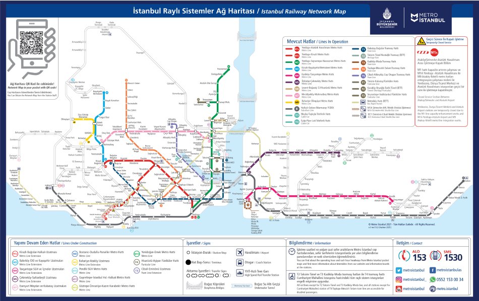
Map of public transport, and useful application for getting around
To download the map of public transport in Istanbul in PDF and JPG, click here.
Useful application: To help you move around Istanbul we can advise you on the City Mapper application. A little less reliable, and less complete, Google Maps is not bad either.
The Istanbul kart (transport card)

Istanbul Kart
In order to use all public transportation in Istanbul (boats, subways, buses, tramways, funiculars), you will need the magnetic card, Istanbul Kart. You can find it in the small kiosks near all metro stations, piers, and also bus stations. It costs 70 TL, you will then add credit. Keep in mind that most trips cost approximately 17 TL each way. For more information you can visit the website of the municipality: https://www.iett.istanbul/en If you buy a card with a limited number of trips, you can do it directly in front of the turnstiles. The prices are 25 TL for one way, 45 TL for two ways, 70 TL for three ways, 105 TL for five ways, and 200 TL for ten ways.
THE MODERN TRAMWAY
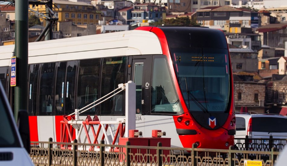
On the European side, there are two lines in service, the T1 line from Kabataş allows easy access to Sultanahmet and the T4 line that goes North – West of the city. It runs from 6 am to 11 pm. The tramway in Istanbul is very clean and has air-conditioned.
The T1 line will allow you to reach the main attractions of the city. We recommend you using it as it is really cheap and fast and definitely the easiest way to get to the old town. The main stops of T1 are:
- Kabataş — Dolmabahçe Palace, Taksim connection with the funicular (F1) to go to the pier to the Princes’ Islands and Kadıköy.
- Tophane — Museum of Modern Art in Istanbul.
- Karaköy —Connection Tünel funicular, (T) which will drop you on Istiklal Street.
- Eminönü — Spice Market.
- Sirkeci — Train station and connection to the Marmaray.
- Sultanahmet — Topkapı Palace, Hagia Sophia, Blue Mosque, Basilica Cistern, Archaeology Museum.
- Beyazit — Grand Bazaar.
- Zeytinburnu — Connection M1 .
Another line that may be of interest is the new T5 streetcar line. It will take you to the districts of the Golden Horn, such as Fener and Balat, or to the foot of Pierre Loti Hill, where you can take the funicular up to the cemetery. The main stops are:
- Eminonü — Departure/terminus, Spice Market – Connection with tramway T1
- Fener — One of Istanbul’s most fascinating districts, once predominantly populated by Greeks.
- Balat — Right next to the Fener district, historically populated by the Jewish community.
- Eyüp Sultan — Here you can take the funicular to Pierre Loti’s hill.
THE FUNICULAR
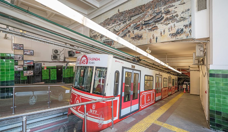
Karaköy’s funicular
– Karaköy-Tünel (T): It allows you to go quickly down Istiklal Street and you will avoid climbing the slopes to get in neighborhoods like Galata. Once in Tünel, you can use the historical tram (NT) to go to Taksim Square. It runs from 7 am to 9 pm.
– Taksim-Kabataş (F1): It allows you to go from Taksim Square to Kabataş. From here, you can take the tramway (T1) to get to the old town, and the boat to the Princes’ Islands from Kadıköy. To go to the old town, another option is to take the M2 metro directly to the Golden Horn (Haliç stop) from Taksim.
THE HISTORICAL TRAMWAY
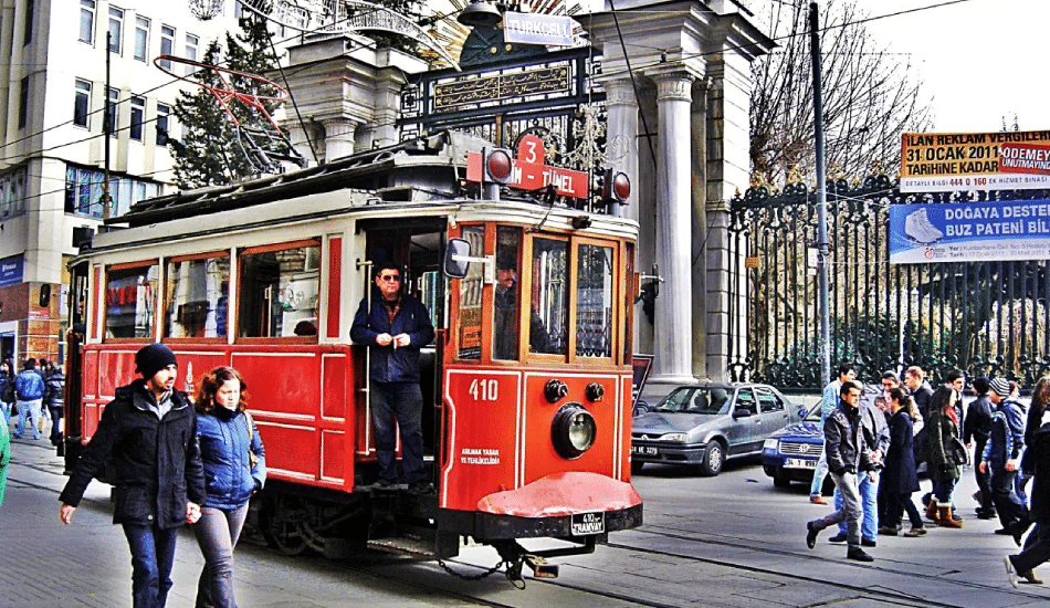
Taksim Tramway on Istiklal Street in Istanbul
They look like trams out of an old movie, two lines are in service: the first on the European side (NT) which runs down the Istiklal Street from Taksim Square to Tünel, and the second (T3) is on the Asian side from the pier and it goes from Kadıköy to the Moda neighborhood.
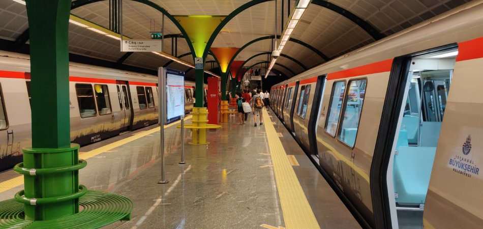
THE METRO (SUBWAY)
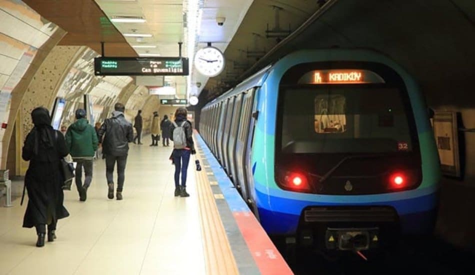
It is open from 6:15 to midnight, there are currently two lines on the European side. Unfortunately, these two lines are not connected yet. There is also a line on the Asian shore (M4) but it is not of great interest to you because it is not connected to Sabiha Gökçen Airport yet.
– Atatürk airport – Aksaray (M1): This metro line mainly allowed tourists to get to the center of Istanbul from the old airport on the European shore – Atatürk Airport – via Yenikapı station to reach the M2 metro. From now on, Atatürk Airport only accepts cargo and VIP passenger flights. As the new Istanbul airport (IST) is not served by the metro yet, this line is not essential for walking in the city of Istanbul.
– Yenikapi-Hacıosman (M2): It is the longest metro line in Istanbul and the one you will use the most. This is the one you need the most during your stay. Since the beginning of the year, it has been lengthened, it is now possible for example to get to the old city from Taksim Square and more. This is especially useful for businessmen residing in the district of Levent, or for travelers who have chosen to reside in more Turkish and less touristy areas like Nisantasi. Taksim Square is now only 2 stop Eminönü district where the spice market is located. The main stops of the M2 are:
- Yenikapı — This station is intended to be the hub of transport in Istanbul. You can already use the Marmaray from Yenikapı (the metro passing under the Bosphorus ) to reach Üsküdar on the Asian side.
- Haliç — This is the most useful station for tourists wishing to reach the old town or for those wishing to go from the old town to other areas that seem less accessible. You will be near the spice market and Eminönü tram station (T1).
- Şişhane — Located at the bottom of İstiklal Street, it will allow you to reach the Tünel funicular located right next to the station, as well as the Galata district.
- Taksim — Located in Taksim Square, the station can be reached quickly by foot from the districts such as Cihangir, Beyoğlu or Çukurcuma. You can also use the funicular (F1) to get to Kabataş where you’ll take the ferry for Asia and the Princes’ Islands, and the tram (T1) to get to the old town.
- Osmanbey — Located just minutes from the upscale Nisantaşı district. Very nice area with many bars and restaurants as well as luxury shops and many Turkish designers.
- Levent — This is the business district of Istanbul. There is also close to the metro two major shopping malls: Kanyon and Metrocity.
- İTÜ Ayazağa — Located near the chic shopping gallery İstinye Park (you need a little walk or take a taxi or a minibus). This gallery is a paradise for all lovers of fashion and luxury, you will find all the most luxurious brands.
– Marmaray: After long years of work, the European side and the Asian side are now connected by the metro which passes under the Bosphorus. It allows you to go to the Asian shores from Yenikapı or Sirkeci. Two stops from the Asian side are Üsküdar and Ayrılık Çesmesi. You can use the M4 to get to the Kadıköy district.
THE BUS
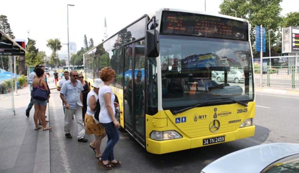
Istanbul bus
There are 400 bus lines in Istanbul, the majority work until midnight every night. Except for Sultanahmet (accessible by tram), buses go all over the city. Destinations and major stops are written in yellow on the sides of the buses.
For information on bus timetables and to see where they stop click here.
THE METROBUS
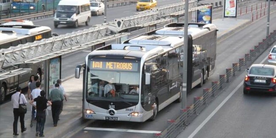
Istanbul Metrobus
These are buses that run on reserved lanes to avoid congestion. Most of the areas served are on the outskirts of the city. Therefore, its use is not of great interest if you are visiting the city. Only the Istanbul Kart and the Mavi Kart (which is for monthly subscriptions) are accepted to access Metrobus. You can buy or recharge your Istanbul Kart at all stations.
THE PUBLIC FERRY
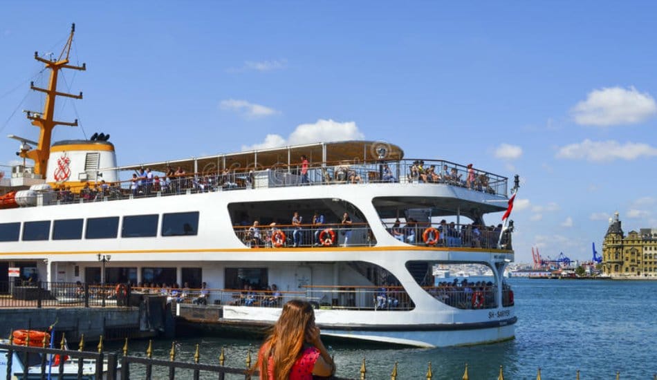
The public ferry, “vapur” in Turkish
They allow you to move from Europe to Asia. As with the metro, Istanbul residents use public boats/ferries – “vapur” in Turkish – every day and save considerable time by avoiding constant traffic jams on the two main bridges of the Bosphorus. By taking the ferry, you will realize the vastness of the city, it is also a good way to see the city from the water at a lower price. The main piers on the European side are Eminönü, Kabataş, Karaköy, and Besiktaş, and on the Asian side, Üsküdar and Kadıköy.
Unlike the metro, Metrobus, and certain bus lines, ferries are in service between around 7 am till midnight (depending on the pier). You can use your Istanbul Kart to access the boats.
These public boats are also useful for reaching the Princes’ Islands for the price of 58 TL: One day in the Princes’ Islands.
For more information on timetables, click here.
If you want to cruise on the Bosphorus (see our article in the section “Ideas for days in Istanbul”: The Bosphorus). We advise you to take the boat from Beşiktaş or Ortaköy rather than the one from Eminönü which is always full and less comfortable.
THE DOLMUŞ
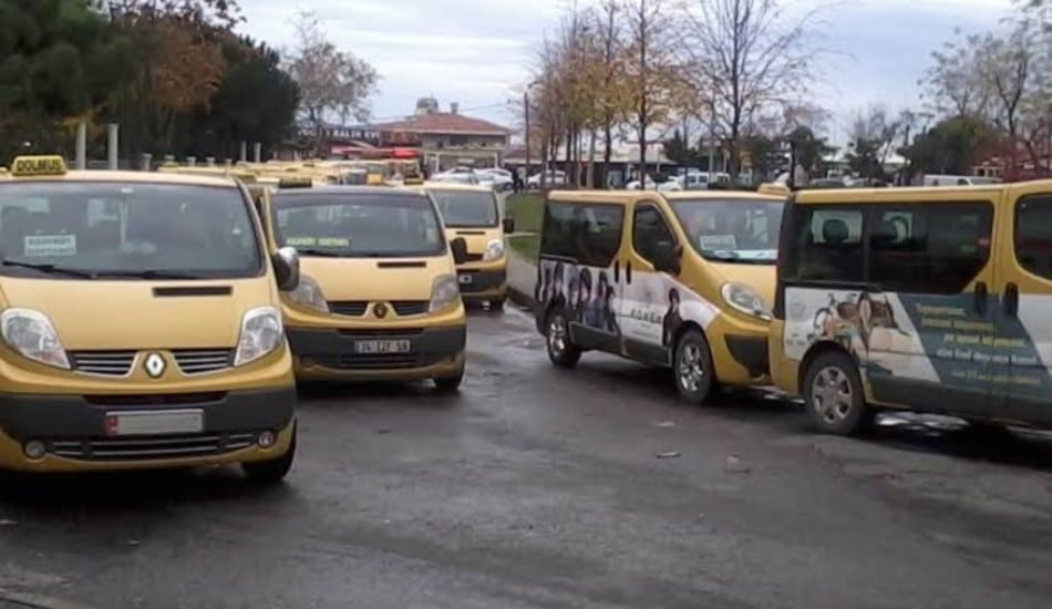
Dolmuş in Istanbul
These are shared taxis that operate 24/7. It is fast, economical and widely used throughout Turkey. They run on a specific path and leave when they are full (8 passengers). On the way, you can get out wherever you want. The payment method is simple, once seated, state your destination to the driver who will tell you the price and hand him the money (only cash is accepted). The main dolmuş lines are in Europe: Beşiktaş – Taksim; and Taksim – Bakırköy, Yeşilköy; Sarıyer – Beşiktaş and Kadıköy and Üsküdar from Asia. There are also lines connecting Europe to Asia from Beşiktaş and Taksim.
We hope this article will help you get around this huge city of Istanbul. If you have any questions, you can ask us them in the comments so that all readers can benefit from your questions and our answers.